
 Trentham has changed from a village to a suburb within a century but at its heart is a settlement that historical evidence suggests is at least 1,300 years old located close to the river Trent at its junction with two smaller tributaries Park Brook and Longton Brook. Administratively, there are two distinct communities sharing the name Trentham, as the land to the west of the River Trent is in Stafford Borough, whilst that to the east of the river and the A34 road is part of the City of Stoke-on-Trent.
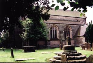
The churchyard, pictured above, was at the centre of the life and land of an early community. The ecclesiastical parish boundary still encompasses an almost equal area to the east and west of the river and to the north and south of the church (which is a grade 2 star listed building designed by Sir Charles Barry) despite being much reduced in size due to the creation of daughter parishes as the population grew, especially in the nineteenth century.
Trentham was once considered of sufficient strategic importance to be claimed by kings. The earliest known document records that St. Werburg (niece of the Saxon King, Ethelred) was given control of a priory in Trentham in AD 680. When William of Normandy ordered an inventory of his English domains in around 1086 (now known as the ‘Domesday Book’) it noted that the ‘king holds Trentham’. The King’s estate is said to include land big enough for three and a half ploughs, managed by a Reeve who had 6 people in his service. Trentham also included an area of 3 ploughs and woodland of more than 1 square mile supporting a priest, a ‘free man’ (i.e. a man of property, possibly of noble descent) and 9 other people.
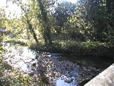 There is physical evidence of even earlier settlement in the vicinity as a bronze sword was discovered at Hanford and there are two ancient burial mounds on the west bank hillside on either side of the modern Whitmore Road. The churchyard, like many Celtic religious sites, is at the junction of two streams, with another stream joining from the other direction a short distance below. In Welsh, this meeting place of three valleys might be called Trinant and it is possible that the names of both the river Trent and Trentham are derived from this. During the Roman occupation of Britain, two roads met
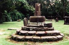 close to the spot pictured above, one running north to south by the river and the other connecting the important settlements at Derby and Chester. The Saxon Cross in the churchyard (right) is said to commemorate a Queen, whose body lay in the church on its journey to interment elsewhere.
In the years between the Norman Conquest and the dissolution of the monasteries (that took place during the reign of Henry VIII), the Augustinian Priory at Trentham (said to have been founded in 1150) acquired considerable surrounding lands, stretching northwards towards what is now the Town of Newcastle-under-Lyme. After the dissolution (which took place between 1536-1539), much of this property was purchased by the Leveson family, whose descendents eventually received the Dukedom of Sutherland, as well as many subsidiary titles including Viscount Trentham. By the 1840s, the second Duke was reputed to be one of the richest men in Europe, particularly as a result of the income he received from the coal mines on his land. He built a statue (erected in 1836, designer Winks and sculptor Chantry) to commemorate his father, the first Duke, which overlooks the village of Tittensor, on the west bank of the Trent and also a palatial hall and 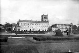 gardens (constructed between 1833 – 42 and photographed, left in 1900 – courtesy of the Francis Frith collection), employing Sir Charles Barry (who also designed the British Houses of Parliament) as his architect. Trentham Hall was demolished in 1911 by the fourth Duke. The second Duke also paid for the rebuilding of the neighbouring church of St May & All Saints, completed in 1844, which was remodelled to be more in keeping with the style of the Hall. Even so, Barry retained some
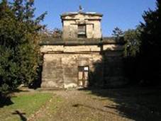 of its earlier features, such as the Norman stone columns, mediaeval porch, Tudor rood screen and the base of the Saxon Cross, which was relocated to its present position. A family mausoleum (right), which is now a Grade 1 listed building (architect: Charles Heathcote Tatham) and has been recently restored, had been built, around 1807-8, across the river using local red sandstone blocks quarried on the estate at Beech.
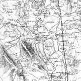 Even in Victorian times Trentham was recognisable from the Domesday Book description of agricultural land and woods, as shown by the frequent occurrence of the words ‘wood’ and ‘plantation’ in this extract from the first edition of the one inch Ordnance Survey map of Staffordshire, which includes some revisions up to 1890.
The larger scale map, dated 1900, see below, shows the extent 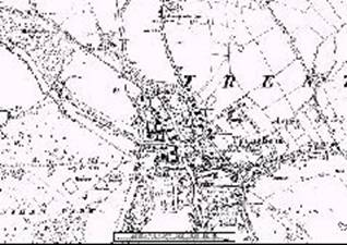 of such development as there was, which was concentrated around the Duke of Sutherland’s estates, centred on Trentham Hall, and a small number of dwellings just across the river Trent in the area then known as Ash Green. Even today, some of these cottages remain beside the A34 at its junction with the Longton Road (two were re-thatched in the summer of 2003) but their front gardens have been greatly reduced to accommodate road widening that took place about forty years ago. The Mausoleum remains but the Institute and school disappeared when the A34 was widened to become a dual carriageway.
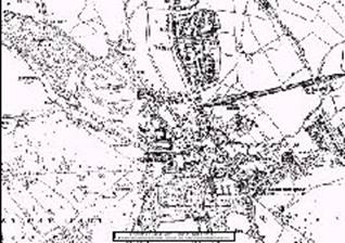 By 1938, when the map, left, was published, development had just started on the ‘Dairyfields’ housing estate on the west side of the river Trent (building round the ancient burial mound shown on the previous map). There was more new housing on the other side of the river to the north of Trentham Park railway station (itself a new addition to the landscape), around New Inn Lane (towards the right hand edge of this map) and on the eastern side of Barlaston Old Road, just off the map. This development attracted relatively wealthy businesspeople and professionals to move to Trentham from the city centres of Stoke and Newcastle-under-Lyme, to the north. The Hall had been demolished but the Gardens had acquired a new use as commercial pleasure ground. They remained in the ownership of the Sutherland family, who eventually sold their Trentham estates in the 1980s.
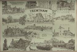 It was from the 1960s onwards that the development of new housing estates began to fill the fields behind the ribbon development along the roads on the east side of Trentham: starting in the area closest to the river and then gradually working further east until it has begun to merge with development spreading west from the neighbouring village of Blurton. The line drawing to the left dates from the mid 1960s and shows many of the buildings and views that have been lost.